
A STRENUOUS walk with a long climb and steep descent. There are also a number of narrow stone stiles and paths that have tree roots.
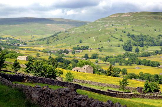
THE most northerly of the dales, Swaledale and Arkengarthdale, have perhaps the wildest, most unspoilt scenery in the Yorkshire Dales National Park.
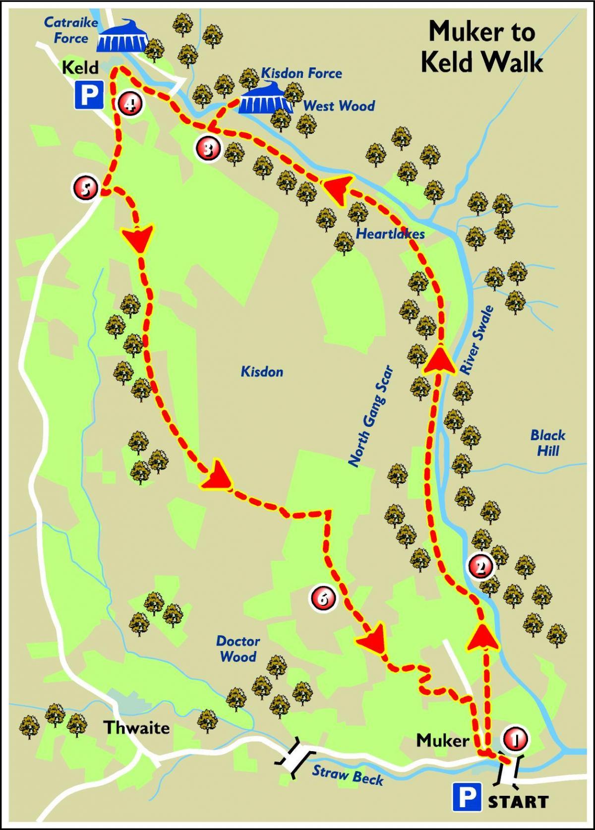
And that is where we start this week's walk - in the village of Muker, nestling below Kisdon Hill.
It is the perfect place to explore the area. The heart of Swaledale is the River Swale, one of the fastest rising flood rivers in England with a fearsome reputation for washing away bridges and unwary travellers.
Today it flows through traditional haymeadows bright with wild flowers in the spring and dotted with carefully preserved stone field barns.
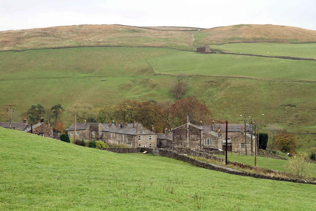
Muker boasts a fine Literary Institute - now the village hall - an inn and the Swaledale Woollens shop. The latter is a remarkable local venture that has helped save the Swaledale Woollen industry by marketing locally-made clothing from the hard-wearing wool of the native Swaledale sheep.
Our route takes us to Hartlakes, reputedly one of the most haunted buildings in the country. Its other name is Boggle Hall, "boggle" referring to the old name for a spirit that moves from house to house. So watch out for the ghosts!
Another highlight is Keld, a small, compact village at the crossing point of the Pennine Way and Coast to Coast paths.
There are no less than four fine waterfalls within a short walk of the hamlet. Wain Wath and Catrake Force are up river, East Gill is on a side valley, and the almost hidden twin waterfalls of Kisdon Force are secreted within a thickly wooded, limestone gorge downstream.
Our route allows a detour to the latter before we join the old Corpse Way, which led to the nearest consecrated ground at Grinton before St Mary's Church was built in Muker in 1580.
This walk has been provided by the Yorkshire Dales National Park Authority and further walks in the area can be found at yorkshiredales.org.uk
Step by step
1. Go up through the village and turn right by the small post office. Take the flagged path, signposted to Gunnerside and Keld, across the meadows until the river is reached.
2. Go through the stile, down the steps and turn left, signposted Footpath, and follow the waymarked route upriver passing several disused farm houses, one of which is Hartlakes which is reputedly one of the most haunted places in the country. This part of the walk takes you through the old wood pasture of Muker, the remains of which, especially pollarded (a pruning system in which the upper branches of a tree are removed) Alder, can be seen on the opposite side of the river under West Arn Gill.
3. Before joining the Pennine Way National Trail, a detour can be taken by following a signposted path off to the right, to Kisdon Force waterfall, a spectacular waterfall after heavy rain. Take care down the narrow slippy path. Retrace your steps and continue ahead to the hamlet of Keld.
4. Leave the village heading southeast to the main Reeth to Kirkby Stephen road. Near the War Memorial, turn left at the road junction and follow the tarmac road, signposted Reeth and Richmond, for a 400 metres (¼ mile).
5. Take the track on the left, signposted Bridleway Muker 2. This is the old Corpse Road which led from Keld to the nearest burial ground at Grinton, until St Mary's church was built in Muker in 1580. Follow this track down hill and over a small footbridge. Continue ahead and start the climb onto the shoulder of Kisdon Hill. The route eventually levels out with extensive views down Swaledale, before dropping down to join the Pennine Way near Kisdon House.
6. Continue down the hill, signposted to Muker, until the village is reached and retrace your steps back to the car park.
Distance: 8.5km (5.5 miles)
Time: a minimum of two-and-a-half hours
Parking: car park at Muker next to the bridge
Toilets: Muker and Keld
Refreshments: pub and shop in Muker, café at Keld


Comments: Our rules
We want our comments to be a lively and valuable part of our community - a place where readers can debate and engage with the most important local issues. The ability to comment on our stories is a privilege, not a right, however, and that privilege may be withdrawn if it is abused or misused.
Please report any comments that break our rules.
Read the rules here