
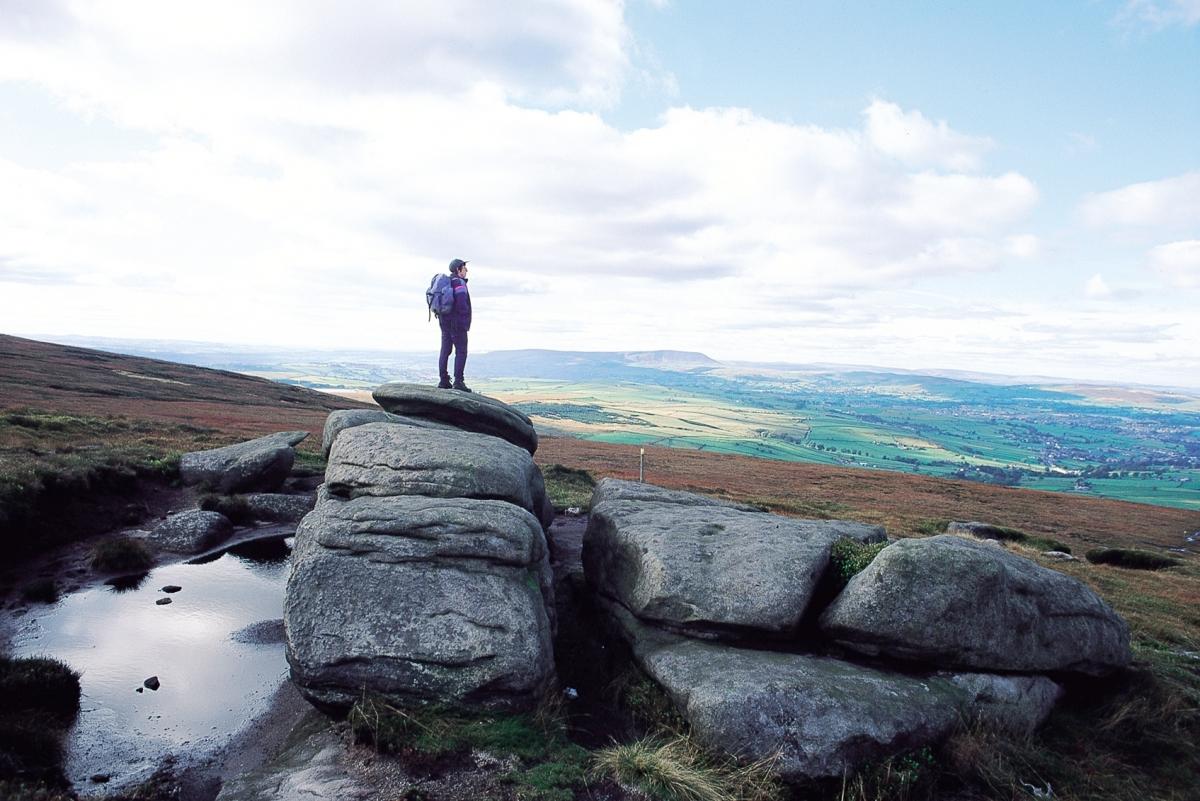
GOOD views, gritstone outcrops, Brontë moorland, patchwork fields, wooded valleys and a hidden waterfall feature on this energetic circular walk.
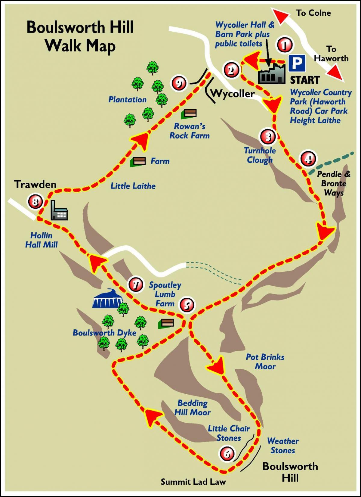
THIS week's walk starts at the Wycoller Country Park Haworth Road car park at Height Laithe, which is approached from Laneshaw Bridge, on the Lancashire and Yorkshire border not far from the historic market town of Colne.
In Norman times this whole area was a vast hunting ground. In the 13th and 14th centuries monastic cattle farms were established, which grew into the settlements of Trawden and Wycoller.
The traffic-free village of Wycoller has been a source of inspiration for authors, poets and painters.
Ancient bridges cross over a pretty beck.
The ruined Wycoller Hall is believed to have been the inspiration for Ferndean Manor, in Charlotte Brontë's novel Jane Eyre.
Wycoller is on the Brontë Way, which stretches from Lancashire into Yorkshire.
Step by step
1. Park in Wycoller Country Park Haworth Road car park at Height Laithe (GR 936394). Go down the steps and path. Go left at the fork.
2. From Aisled Barn, turn left on the broad track with Wycoller Beck on your right. Go past two stone bridges. Carry on, following the beck to cross another bridge (near the Brontë Way and Pendle Way signs).
3. Take the Gawthorpe Hall direction over the stile by the stream (not up the winding track). Continue with stream on right, cross the stream by a footbridge and go left to follow a fence. Eventually, cross the fence by a stile and turn right, continuing with the stream on your left. Go through a kissing gate, and follow the fence to a stile by the stream. Go up rough steps above the stream and continue along Turnhole Clough.
4. The route joins the Pendle Way (symbolised by a witch) and Brontë Way. Continue in the same direction as before, into open moorland; along the track, sometimes paved, and eventually with a drystone wall on the right. Continue for about half a mile. The long line of Boulsworth Hill is on your left.
5. Descend to join the metalled farm track (by a Pendle Way sign) and continue to Spoutley Lumb Farm, which marks the ascent to the summit. Turn left on to the North West Water Authority's concessionary access concrete path. At the building, follow the way-marked route on the left, passing through a gate and then climbing steeply up the slopes of Pot Brinks Moor. The gritstone outcrop of Little Chair Stones is reached, with its huge wind-carved boulders providing a fine vantage point.
6. Follow the way-marked route to the right, leading to another outcrop, Weather Stones, then on to the summit. The descent - continue past the trig point, bearing right on the path, and Upper and Lower Coldwell Reservoirs come into view. The waymarked route descends to the Pendle Way at the bottom. Turn right and walk back to Spoutley Lumb Farm and soon after, over the ladder stile on the left, following the Pendle Way across a second ladder stile. At this point, turn half right to find a thin track, down to a concrete bridge.
7. Before crossing the bridge, go about 100m left downstream, to where the land falls away. Follow the sound of Lumb Spout to view the waterfall in its wooded hollow. Return to the concrete bridge and cross the stream. Pass over two fields and through a farmyard, down a track to join a road.
8. After about half a mile you reach Hollin Hall Mill. At the far end of the Mill, follow the public footpath sign to the right. Just over the second cattle grid, go forward through a small wooden gate, and straight on over the field to cross a stone stile to the right of Little Laith Farm. Follow the arrow sign through the gate and continue with the farm on your left.
Follow the footpath signs, passing in front of the next farm (Germany). Keep straight on, over stiles and footbridges, finally passing Ravens Rock farm on your right.
9. Pass through the plantation of young trees, down the steps and turn left to arrive back in Wycoller.
Fact file
Start: Wycoller Country Park Haworth Road car park
Distance: 8 miles (13km). Allow at least 4 hours.
OS map: OS Outdoor Leisure Map 21 South Pennines (double sided map).
Refreshments - Wycoller and Hollin Hall Mill.


Comments: Our rules
We want our comments to be a lively and valuable part of our community - a place where readers can debate and engage with the most important local issues. The ability to comment on our stories is a privilege, not a right, however, and that privilege may be withdrawn if it is abused or misused.
Please report any comments that break our rules.
Read the rules here