
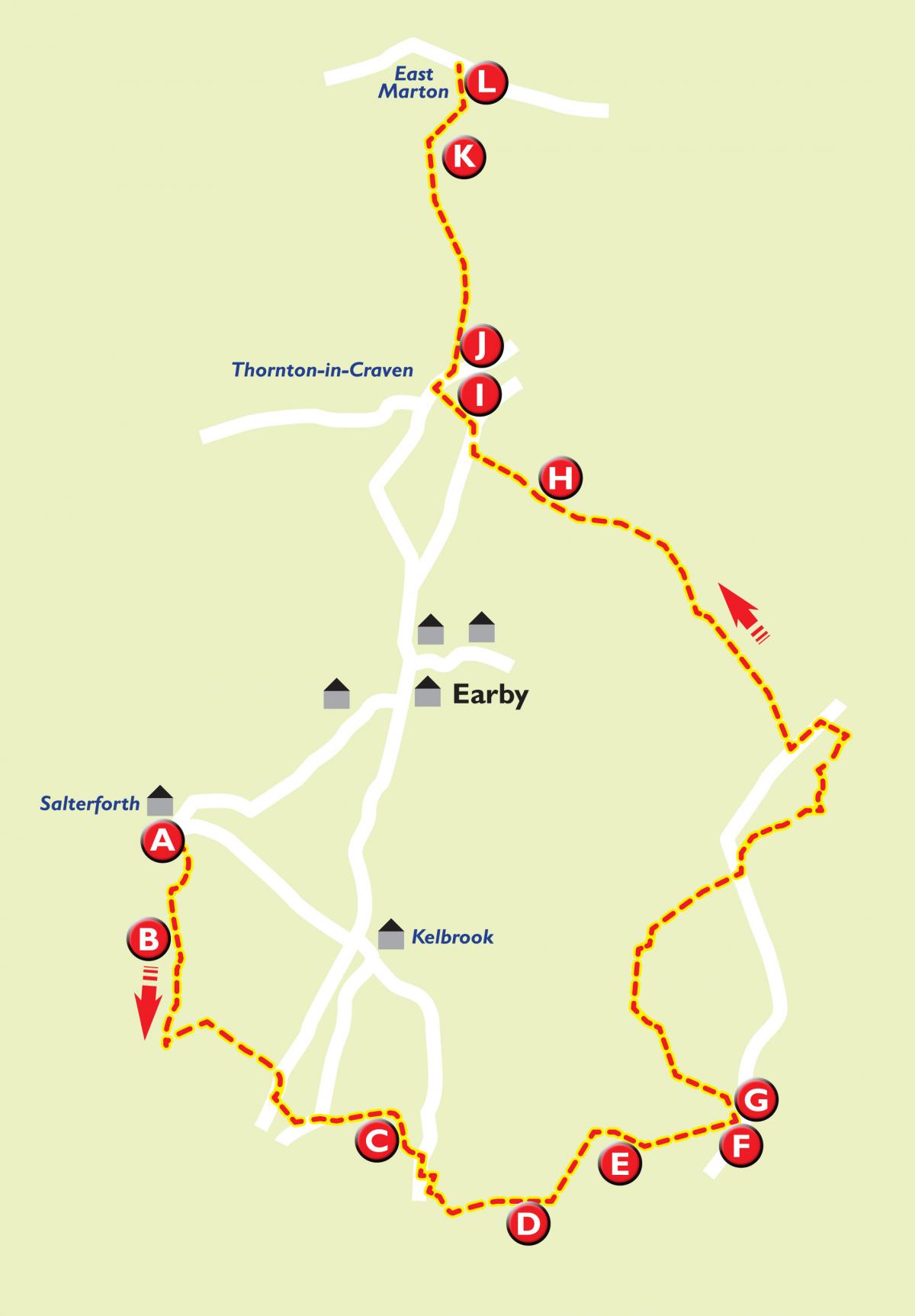
THIS week, we tackle part one of the West Craven Way.
It covers a 12-mile stretch, starting at the Anchor Inn, Salterforth and finishing at the Cross Keys, West Marton. It explores the area to the south and east of Barnoldswick.
Part two will be published next week.
They are among a number of walks promoted by Pendle Council. For more walks, log onto visitpendle.com or call into one of the council's tourist information centres.
Step by step
(A) On the towpath of the Leeds and Liverpool Canal (B), turn left under the bridge and continue for about a mile to Mill Hill Bridge. Go under the bridge and turn left to leave the towpath. Do not cross bridge but proceed to the stile to the right of the gate. Follow track, turning right along field edge. Cross the footbridge and head across the field towards the farm buildings. Follow the track over the disused railway, through the farmyard to the A56.
Turn right towards Foulridge. Once past the cottages, cross the road and go through the gate by the bus stop. Head diagonally right to the stream. Over the stile, turn left before the stream, follow the stream to a small ladder stile. At the road, turn left, then right, through a squeeze gate and follow the footpath up the gully, through a stile gate, until you reach the wall. Continue to the right of wall until you reach the gate. Go through and turn right over the Lancashire Ghyll (C). Follow the path up and over a stile, past Oxenards. Go over the stile, cross the lane and over another stile. Bear left up the field to a track, turn left through the gate. Turn right up the lane to the brow of the hill and turn left over the stile onto the footpath to Throstle Nest.
At the edge of the garden, take the stile to the right and follow the track away from the house. After 200 metres, turn left down to the stream. Cross the footbridge and turn right following the stream. Past the old quarry, turn left and, with the stone wall on your right, go up Great Edge (D) to a ladder stile, now keeping a fence to your left. At the next stone wall, go over the ladder stile and downhill. Then as you start uphill, go left over the ladder stile then bear right across the field to a stile.
Over the stile, continue over stone steps and go left across the field and follow the track across the next field. Before the ladder stile, turn right through the gate and along the lane, passing to right of Copy House (E) (Hawes Farm). Go over two stiles and continue uphill to another stile. Go straight on over the hill and over two more stiles towards Black Lane Ends (F). At the gate, follow the wall left onto the Pendle Way (G). Go through the gate and follow the path down the field and then left towards Scald Bank Farm. Over the stone stile, turn left and take the track round the back of the farm, over a stile and across the hillside, making your way down to the stream.
Over the footbridge, turn right over the track through the gate into the garden of Harden Clough. Follow the gravel path past the house and over the stile. Proceed across the field to midway, at the line of bushes, and turn right down to the stream. Cross the stream and go uphill and over the stone stile. Turn left over wooden bridge, then immediately right and follow the field fence uphill. At the end of the field, turn right through the gate and follow the bridleway turning left at edge of the gardens.
As the track turns left across the front of the houses, bear right to a small ladder stile in the wall. Go over the stile and slightly left across the hill turning left towards buildings after passing through next squeeze stile. Over next stile, turn right across the front of Bleara Side to Bleara Road, turn right. Turn left at the T junction and right through Salt Pye Farm entrance. Follow the track until it turns right to the farm, here go straight on through field gate and bear right across field and over stone stile.
Still bearing right cross this field, go through wall, via a squeeze stile. Bear left across this field, through a gate and left downhill to Bent Hall Farm. Go over the stile to farm track and left through the gate, past farm buildings and through another gate into field. Bear right uphill to a laddered gate. Through the gate, go uphill to a gate next to the house. Through the gate, turn right over the stile and bear left across the field, over another stile, then follow the wall up to Proctor Height Farm. Cross the front of the building onto the track. Follow this as it turns left and uphill to the road.
Turn left onto the road until you reach Dodgsons Lane. Turn right past Dodgsons Farm. Follow the track through a gate and downhill, through the next gate cross the stream then proceed up over stone stile into field. Precede diagonally left to the left of barn to a gate above gully. Through the gate, follow track round to left, past old farmhouse, over stream and uphill turning right before gate following grass track. Over next stile, keep to grass track with stream down to right.
At the bottom of field go right through gate and over bridge. Follow track then bear left across field heading to left of Oak Slack Farm. Pass through field entrance then through squeeze stile and up to track. Turn left and follow track uphill. Over cattle grid turn right through gate and immediately left along grass track. Keeping the gully to left carry on downhill to telephone poles, here leave gully and go directly downhill to track leading into trees. Follow track over bridge and through gate, past farm buildings onto Booth Bridge Lane (H).
Follow Booth Bridge Lane over old railway line up to A56 in Thornton-in-Craven (I). Carefully cross the road and turn right passing the Old Post Office. Turn left onto Cam Lane following the Pennine Way. Keep to the lane for three quarters of a mile. Where the lane bears left and passes farm buildings, turn right through a gate into field. Proceed diagonally left, still following the Pennine Way, pass through gate and go downhill to a stone footbridge. Over footbridge and two stiles, cross track and go right across slope. In the corner of field, cross stile and continue over the brow of the hill and down to stile and plank bridge in the right hand corner of the field. Over the stile walk up to canal towpath. Turn right to Bridge 160 (K). Cross bridge towards St Peter’s Church (L). Through gate head for stile to right of churchyard. Over the stile, turn left and follow the line of an old wall and new trees to a gate onto A59. Cross road to Cross Keys Pub.


Comments: Our rules
We want our comments to be a lively and valuable part of our community - a place where readers can debate and engage with the most important local issues. The ability to comment on our stories is a privilege, not a right, however, and that privilege may be withdrawn if it is abused or misused.
Please report any comments that break our rules.
Read the rules here