
OUR latest railway walk offers the perfect opportunity to see the landscape of the Bentham Line at work.
It is one of 12 Rail to Trail walks put together by the line, with the backing of the Leeds-Lancaster-Morecambe Community Rail Partnership, Lancaster and Skipton Rail User Group and Northern Rail.
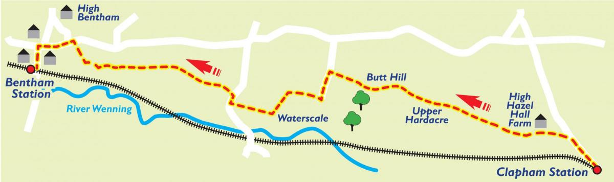
It starts at Clapham Station and wends its way through fields and working farms to the market town of Bentham.
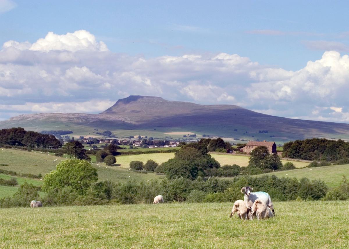
And there are glorious views of Ingleborough - one of Craven's famous Three Peaks - for much of the route.
The walk has been compiled by Stuart Ballard and other walks in the series can be downloaded from communityrailancashire.co.uk/walks/self-guided-walks
Step by step
Leave Clapham station through car park. Turn left along road. Ingleborough (R). Just past Nutta Farm (R), turn left over bridge, under which used to run the line to Ingleton. Follow the road round to the right and fork right onto a green path going up the hillside, which soon leads into a narrow path. Follow this narrow path straight up to the top of the hill.
High Hazel Hall Farm can be seen below. Follow a path down directly towards it. Join farm track and veer right over cattle grid, pass in front of farm house (R) and converted barn (R) and go through field gate. Pass sheep pens (R) and wall (L).
Continue along wall in this long field to top left of field, ignoring any gates to left. Pass water trough in wall (L) and cross wall stile into open access land and keep straight on for a few metres before veering right uphill, away from wall (L). Initially head up towards far right of field barn at the far wall. The path winds up to the fence (R). Turn left at this fence and follow it along to a field gate in wall to exit open access land. Go through gate and head across three fields with gates and stiles towards Upper Hardacre farm.
Pass back of farm (L) and, at end of long barn, turn left and exit field through gate. Turn right and follow partially sealed track past bungalow (R). Cross cattle grid and continue on track through open access land. See Ingleborough (R). Follow track around Old Butt (R) and join sealed road. Pass Butt Hill (glacial deposit) (R). Pass Sherwood House and Barn access track (L), and Chesters (R). At T-junction turn left at public footpath post, cross cattle grid and follow track down to Meregill.
Go through gate into yard. Immediately turn right and go through a narrow gate, next to a water trough, into narrow field. Farm building (L). Keep close to wooden fence (R) and go straight ahead to next stile. Cross into field and keep close to ditch and hedge (R). Cross step stile in fence, veer left towards house in trees. Cross step stile, bath water trough (L). Join track, house (L), and follow it around side of house to gate, continue down track to Waterscales farm yard. Turn right and leave farm on sealed drive with four cattle grids.
At T-junction with road, turn right uphill. Turn left at first footpath sign and cross stile, veer right slightly up field and pass through squeeze stile in wall (field gate (R)). Veer right again and cross concrete culvert over beck.
Keep straight ahead and pass close to Linghaw Farm buildings (R). Turn right at track at end of building and go towards farm yard. Just before entering yard, turn left over wall stile, and pass in front of house, along wall with ornate fence atop (R), to field gate. Cross field on contour to gate ahead in hedge at the bottom of Batty Farm buildings. Go through gate and veer right across field towards a power pole at the corner of a hedge.
Veer left at power pole and follow hedge (L) along to wall stile. Cross field. Cross stile, veer left down field towards big tree and short wall in far corner. Cross sleeper-bridge, step up wall, cross farm track, and cross step stile into field in quick succession. Cross field towards big tree in next hedge. Cross wall stile to right of tree. Cross field heading for the left hand house ahead. Pass below Fowgill with its monkey-puzzle tree (R).
Cross step stile, veer left and skirt around front of bungalow (R). Go through field gate, veer left and go diagonally to far corner of field. Cross wall stile into narrow enclosed lane. Turn left and follow it downhill. Fork right at information board, go through narrow gate and follow path downhill. Cross gated wall stile with steps down to Fowgill Beck (R).
Cross beck on concrete slab bridge and go straight ahead up towards field gate and gated wall stile. See Ingleborough for the last time (R). Cross stile onto a grassy track between bungalows and turn right down surfaced road. At main road, turn left towards the centre of Bentham. Pass Butts Lane (R). At top of Main Street, turn left down Station Road.
Fact file:
Start point: Clapham Station
Finish point: Bentham Station
Time: 2 hours 20 minutes
Distance: Five miles (eight kilometres)
Total Ascent: 94 metres
Total Descent: 135 metres
Walk grade: moderate
OS Map: OL2


Comments: Our rules
We want our comments to be a lively and valuable part of our community - a place where readers can debate and engage with the most important local issues. The ability to comment on our stories is a privilege, not a right, however, and that privilege may be withdrawn if it is abused or misused.
Please report any comments that break our rules.
Read the rules here