
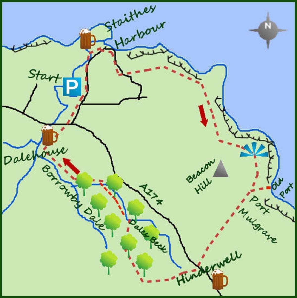
THERE is some of the best and most entertaining coastal walking in the short section between Staithes and Port Mulgrave.
From Port Mulgrave head in land to complete the circular through the woodland of Borrowby Dale.
The walk starts in the lovely fishing village of Staithes. Parking is at the top end of the village but the coastal path is best accessed from the village and the shoreline. Therefore drop in to the tightly packed houses and narrow streets of Staithes.
The village grew up as a fishing village due to the sheltered harbour at the foot of Staithes Beck and fishing vessels still ply their trade. This is where the young Captain Cook worked before heading off on his worldwide adventures.
On reaching the foot of the village do not cross the river (stick to the east side) but follow the road as it bends right to join the Cleveland Way footpath. This climbs steeply out from the village.
After climbing out the village, pass through some houses before arriving at a path junction. Turn left and head towards the coast.
The English Coastal Path is nearing completion (some Covid delays) but was only made possible due to a review of the law on access to the coast over private land.
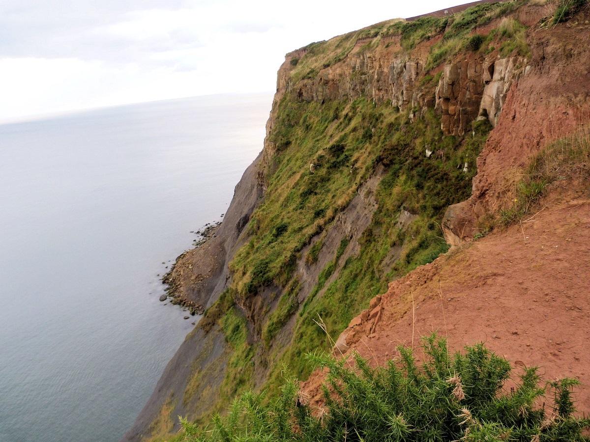
In addition, they added some ‘spreading room’ in lieu of the erosion of the cliff side which is very noticeable on this section of the walk.
The cliffs here are roughly 200ft high. Sticking to the coast the distance to Port Mulgrave is nearly two miles long with some ups and downs typical of the coast. The hill on the right as you approach Port Mulgrave is Beacon Hill.
Continue past the first row of houses at Port Mulgrave to a path on your left leading steeply down the cliff side. Soon arrive at the now derelict harbour of Port Mulgrave.
The harbour was built originally to export ironstone up the coast to the Tyne in 1860. Its popularity declined in the 1920s (and left derelict 10 years later) but there are still the remnants of a more popular age today.
Return up the cliffside path to the houses in Port Mulgrave. Follow the main road as it heads away from the coast, at a T-junction just before the busy A road fork left. Cross the busy road and join a footpath (initially a lane) heading away from the coast.
Ignore a path to your left but continue in to some delightful mixed woodland. This is Dales Beck parallel to the larger Borrowby Dale.
Drop down to a footbridge, cross it and climb for a few metres on the other side. Before leaving the woods take a path to your right heading north and meeting Borrowby Dale itself.
The path continues through the woods for half a mile till it becomes more of a track.
Carry on another 300 metres to a footbridge. Here turn right and climb out of the dale. Re-cross the main road and enter the outskirts of Staithes.
Pick your way back to the car park through the houses of Upper Staithes.
Fact File:
Distance: Roughly seven miles
Height to Climb: 100m (320 feet).
Start: NZ 781186. A large car park in Upper Staithes.
Difficulty: Moderate. A mixed walk along footpaths, woodland trails and larger tracks.
Refreshments: Staithes has a good choice of pubs and cafes, mainly in the lower quarter.
Be Prepared: The route description and sketch map only provide a guide to the walk. You must take out and be able to read a map (O/S Explorer OL27) and in cloudy/misty conditions a compass. You must also wear the correct clothing and footwear for the outdoors.
* Jonathan Smith runs Where2walk, a walking company in the Yorkshire Dales. He has written his own book, the Dales 30, which details the highest mountains in the Dales. He also runs one-day navigation courses for beginners and intermediates.
Join his Learn a Skill, Climb a Hill weekends in the Dales. Visit where2walk.co.uk


Comments: Our rules
We want our comments to be a lively and valuable part of our community - a place where readers can debate and engage with the most important local issues. The ability to comment on our stories is a privilege, not a right, however, and that privilege may be withdrawn if it is abused or misused.
Please report any comments that break our rules.
Read the rules here