
AT this time of the year I love striding out over the moors, covering the miles quickly and enjoying the views in to the distance. One area to do this is west of Masham where the walk covers the rim of Upper Nidderdale and the twin reservoirs of Leighton and Roundhill.
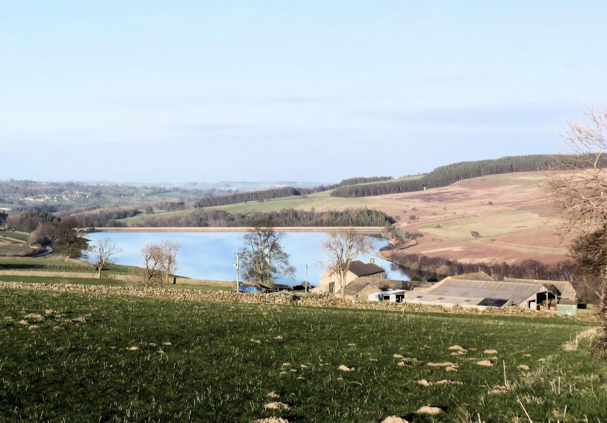
Roundhill and Leighton Reservoirs lie four miles west of Masham. The reservoirs mainly help the nearby River Ure to compensate the flow when water is extracted lower down. Leighton does also supply some water for Harrogate. They are very low at the moment.
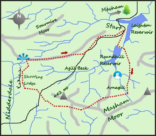
Start the walk at roadside parking just north of the inlet on the western bank of Leighton Reservoir. Head along the road round the inlet to a good track heading initially alongside Leighton before crossing the dam wall of Roundhill. The large tower on the nearby moors is one of three sighting towers, planned to be used in the early 20th century when more reservoirs were planned.
Immediately after crossing the dam, a footpath heads up the fell side, a steep 100 metre climb on a good public footpath. As the path turns south it enters access land but, particularly at this time of the year, the heather is high and the appeal to leave the path low. Fortunately, this walk follows good paths throughout. After one-and-a-half miles, the path meets a major shooting track heading east and west. Turn right and head west. Keep an eye out for Arnagill Tower on your right, down a deep gill.
Follow the shooting track west for two miles. Ignore the track that meets it heading south after one of those miles and instead look around and enjoy the solitude of a classic moorland Dales scene. The track is excellent and largely flat and travels through the grouse moors like an arrow. It is a good place to consider the benefits to the landscape of grouse shooting, it certainly is a memorable stretch of moorland. On meeting another track veer right for a further 400 metres. The trig point 200m to the right is Ouster Bank. Cross a moorland road and carry on west to the rim of Nidderdale.
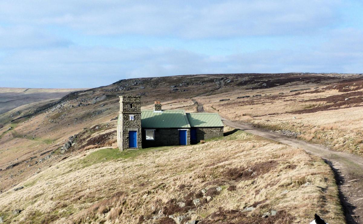
At this point the bridlepath turns north and follows the rim of Upper Nidderdale for in my opinion the most enjoyable mile of the walk. The views over Nidderdale are superb, south towards Pateley Bridge and west in to the wilds of the upper dale. Pass a well presented shooting house, stood overlooking the steep sides of Nidderdale. After the mile a meeting of paths means a turn for home, turn right (east) and start a long gradual drop towards the two reservoirs. The views here are also very impressive and offers a distraction for tired legs.
The path meets a moorland road, after one-and-a-half miles then turn left and follow the road down to the reservoir and your start point.
Fact box:
Distance: Roughly 10.5 miles (17km).
Height to Climb: 360m (1,180 feet).
Start: SE 158788.There is parking on the bend to the north of Leighton Reservoir, before it heads uphill.
Difficulty: Medium/Hard. It is the length that makes this a hard walk, the majority of the walk is on excellent and easy tracks.
Refreshments: There is a choice of pubs and cafes in Masham 4 miles away.
Be Prepared: The route description and sketch map only provide a guide to the walk. You must take out and be able to read a map (O/S Explorer 298) and in cloudy/misty conditions a compass (essential on this walk). You must also wear the correct clothing and footwear for the outdoors. Whilst every effort is made to provide accurate information, walkers head out at their own risk. Please observe the Countryside Code and park sensibly.
Jonathan Smith runs Where2walk, a walking company based in the Yorkshire Dales:
• He has published 2 books on walks in the Dales, ‘The Yorkshire 3 Peaks’ and ‘The Dales 30’ mountains. Available direct from the Where2walk website.
• Book a Navigation Training day (Beginners or Intermediates). All dates and information on the website. Next available date August 13th.
• Join one of the Guiding Days; either the ‘one a day’ Yorkshire 3 Peaks or Helvellyn and Scafell Pike in the Lake District.
Jonathan’s popular website, Where2walk.co.uk also features 100’s of walks across Yorkshire and beyond, from easy strolls to harder climbs


Comments: Our rules
We want our comments to be a lively and valuable part of our community - a place where readers can debate and engage with the most important local issues. The ability to comment on our stories is a privilege, not a right, however, and that privilege may be withdrawn if it is abused or misused.
Please report any comments that break our rules.
Read the rules here