
Jonathan Smith runs Where2walk, a walking company in the Yorkshire Dales.
Jonathan has written his own book, the Dales 30 which details the highest mountains in the Dales.
He also runs one-day navigation courses for beginners and intermediates. Join his Learn a Skill, Climb a Hill weekends in the Dales.
To find out more details on any of the above visit his website, where2walk.co.uk
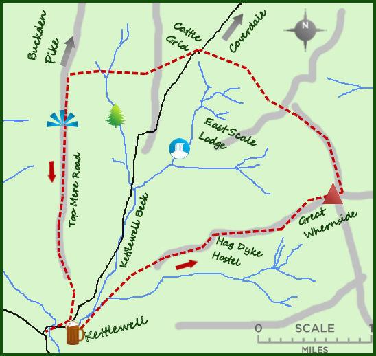
GREAT Whernside is one of 4 impressive mountains that circle the northern end of Wharfedale. They are all part of the ‘Dales 30’, mountains of over 2,000 feet in the Yorkshire Dales. Great Whernside is climbed from the attractive village of Kettlewell.
Kettlewell is nestled under Great Whernside and set on the east side of the River Wharfe. There is a large pay and display car park near the road bridge which marks the start of the walk. From here walk up the road with the Blue Bell on your left and Zarinas café on the right and as you approach the sharp bend of the road carry straight on and cross a small bridge over Cam Gill Beck.
Turn left on a farm track having crossed the road and after 200m a right turn heads up the mountainside. This is where the hard graft starts. The path is direct over some fields, through stone walls and on to one of the broad shoulders of Great Whernside. The path flattens after 400 feet and ahead looms an isolated cluster of buildings. This is Hag Dyke Scout Hostel, the neighbouring chapel being the highest in the country at 1,550 feet. The year 1700 is a rough estimate as to when the original building was built but it could be earlier.
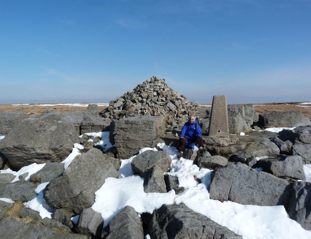
Sadly you are unlikely to be offered a coffee by the scouts (you could ask?) so head on past the hostel and take to the steep slopes above. Having climbed through some rough ground the summit of Great Whernside comes as a bit of a surprise. It is a mass of boulders with a cairn and trig point in its centre. The translation of Great Whernside is ‘hillside where millstones are got’ and clearly there is still plenty to get. It is one of favourite Dales summits.
From the summit take the path north.
It is a fine plateau with steeper slopes to your left in to Wharfedale whilst to the right is a vast boggy wilderness ending in Nidderdale. Avoid. After ¾ a mile walking north, take the path which turns sharply left and downhill next to a stone wall. Soon the path passes through the wall (where it has collapsed and been replaced by a fence) and on to open hillside. The path continues just north of west and drops (initially steeply) to the road from Kettlewell to Coverdale.
The easiest descent is via the road but the best route is to cross the road and follow the path to the north of a stone wall that winds its way west on level ground. The views are exceptional, particularly across to Birks and down Wharfedale. After ¾ a mile there is a meeting of paths and a signpost describing routes to Buckden Pike, Starbotton and your choice Kettlewell.
From here the path improves and descends, soon turning in to a wide track, Top Mere Road. Top Mere Road is now an official ‘green lane’ protecting it from the 4 x 4s and trials bikes which have damaged it in the past.
The track heads like an arrow for Kettlewell.


Comments: Our rules
We want our comments to be a lively and valuable part of our community - a place where readers can debate and engage with the most important local issues. The ability to comment on our stories is a privilege, not a right, however, and that privilege may be withdrawn if it is abused or misused.
Please report any comments that break our rules.
Read the rules here