
Jonathan Smith runs Where2walk, a walking company in the Yorkshire Dales.
Jonathan has written his own book, the Dales 30 which details the highest mountains in the Dales.
He also runs one-day navigation courses for beginners and intermediates. Join his Learn a Skill, Climb a Hill weekends in the Dales.
To find out more details on any of the above visit his website, where2walk.co.uk
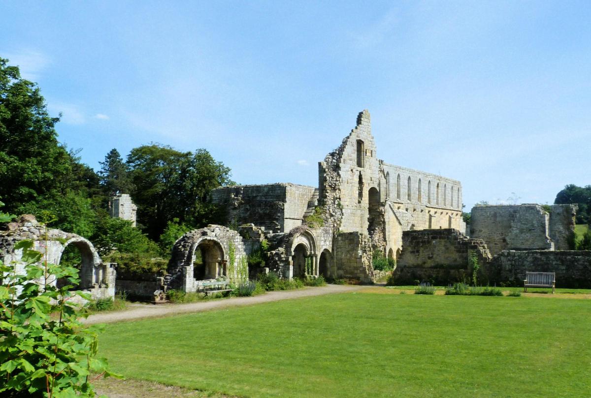
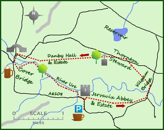
THIS walk along this attractive section of the River Ure starts at the ruins of Jervaulx Abbey and includes sections of riverside and pretty parkland.
Park at the car park at Jervaulx Abbey.
From the car park cross the road (A6108) and enter the abbey grounds.
A voluntary donation is asked for to help with the upkeep of the abbey.
After exploring the ruins return to the donation box and take a path heading east for one mile across the well-kept estate.
There are deer on the estate but mainly sheep; the walking is easy. After passing the gate house on the edge of the estate turn left at the road and follow this down to Kilgram Bridge.
Although it was the monks who originally built this fine bridge if you lean over the side and look carefully in to the running water you will be able to see the foundations of an old Roman road, part of a ford for their legions on their way north.
An ancient legend tells a different story; the devil promised to donate a bridge to the people on the condition that the first living thing to walk over the ‘evil waters’ was given to him as a sacrifice.
An enterprising shepherd swam the river and whistled for his dog to follow over the new bridge; the dog did and became the devil’s sacrifice.
The dog was called Grim, so Kill Grim became Kilgram Bridge over time!
No such risk these days but once across the bridge leave the road and head left over the fields towards the lovely village of Thornton Steward.
Walk through this well maintained village and towards the fascinating St Oswald’s Church, the oldest church in the area, some parts dating back to over 1.000 years.
From here head west through open fields towards another grand building, Danby Hall.
You will be unable to gain entrance to the hall (it is privately owned) but the building is impressive and the grounds, which sweep down to the river, very impressive.
After one-and-a-half miles the estate grounds meet the estate road and some lovely renovated estate buildings.
Turn left at the main road and cross two road bridges, the second being Cover Bridge, another fine pack horse bridge with a pub.
Cross Cover Bridge and immediately tirn left on to the riverside path.
The final one-and-a-half miles of this interesting walk is a real pleasure.
The path sticks close to the River (Cover soon becoming the Ure) as it passes serenely through the landscape of the area.
As well as walkers it is popular with fishermen…do watch out for the legendary ‘kelpie’ fish which leaps out to devour its victims.
The path follows a mix of woodland and open walking before all too soon there is a sharp right turn and a short lane leading back to the café at Jervaulx.
Fact File:
Distance: Roughly seven miles
Height to Climb: 45m (150 feet)
Start: SE 169857. There is a free car park at Jervaulx Abbey but do pop in and enjoy the tea and cake in the café along with the excellent model Jervaulx Abbey.
Difficulty: A low level walk which can be muddy in places.
Refreshments: Either the Jervaulx Abbey café or the Cover Bridge pub, both are excellent.
Be Prepared:
The route description and sketch map only provide a guide to the walk. You must take out and be able to read a map and in cloudy/misty conditions a compass. You must also wear the correct clothing and footwear for the outdoors. Whilst every effort is made to provide accurate information, walkers head out at their own risk.
Please observe the Countryside Code and park sensibly.


Comments: Our rules
We want our comments to be a lively and valuable part of our community - a place where readers can debate and engage with the most important local issues. The ability to comment on our stories is a privilege, not a right, however, and that privilege may be withdrawn if it is abused or misused.
Please report any comments that break our rules.
Read the rules hereComments are closed on this article