
I HAVE always been inspired by the wild moors of the Pennines and can fully understand how the three Bronte Sisters were inspired to write their often gloomy but world-famous novels. They lived in Haworth and this offers a base for this walk, full of interest.
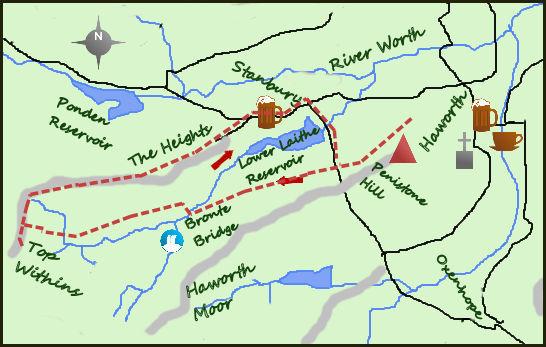
It is possible to park in Haworth and set off from the car park near the Bronte Parsonage. I tend to take the car on to the minor road at the north of Penistone Hill. It shortens the walk and avoids some road walking. Just beyond the cemetery on your left is some parking, leave the car and carry on westwards towards the moors. After crossing a road follow a lane westwards with a dry stone wall on your right signposted to the Bronte Waterfall. Almost immediately you will notice the sandy element of the lane (soon becoming a track) which is a legacy of the hard sandstone bedrock. Further on it becomes like a beach in places!
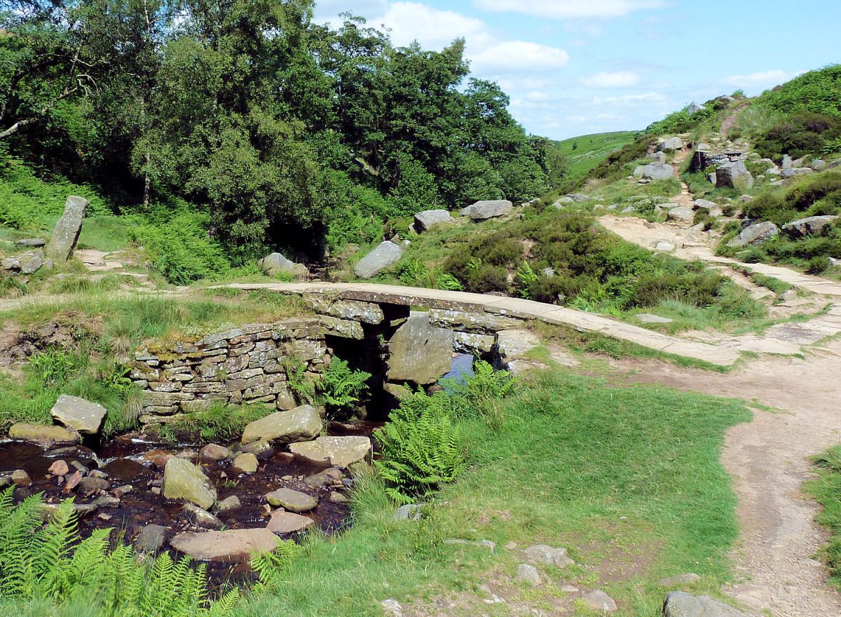
The track continues for one mile before dropping gradually in to a small river bed and an idyllic picnic spot. Here is one of the favourite spots for the Bronte sisters to walk to. On entering this little enclave there is a large stone, the Bronte seat, to the left and a few metres uphill is the Bronte waterfall. Directly ahead is the Bronte Bridge.
Dragging yourself away from this spot is a challenge but do by crossing the river and heading uphill to a stile and a number of footpath choices. Take the one to the left signposted Top Withins.
Follow the footpath for a further mile, turning left when it meets the Pennine Way and you will arrive at the derelict farmhouse of Top Withins. The farmhouse is allegedly the inspiration for the building of Wuthering Heights with its fantastic views. Take a seat on one of the benches and soak it all in, I have never found anyone who is disappointed.
Return the way you came but instead of turning right downhill and back towards the Bronte Bridge carry on along the Pennine way towards the village of Stanbury. This is proper moorland walking, the purple heather at this time of the year is spectacular. The path passes a couple of isolated farms before meeting the main road just to the west of the village of Stanbury. I find Stanbury interesting, not only for the names of the pubs (go and see) but also the mix of derelict properties and those which have been renovated and offer spectacular views over the countryside. Just after exiting the village take the road to the right down to Stanbury reservoir and cross the dam wall before a final steep climb will bring you back on the minor road where you parked the car. Return to the historical village of Haworth (a mile away).
Fact File:
Distance: Roughly 6 miles
Height to Climb: 280m (920 feet)
Start: SE 020370. Park on the minor road leading out of Haworth on its west side.
Difficulty: Medium. On good tracks throughout but take care through the village of Stanbury.
Refreshments: Return to Haworth where there is a good choice of pubs and cafes..
Be Prepared:
The route description and sketch map only provide a guide to the walk. You must take out and be able to read a map (O/S Explorer OL21) and in cloudy/misty conditions a compass. You must also wear the correct clothing and footwear for the outdoors. Whilst every effort is made to provide accurate information, walkers head out at their own risk.
Please observe the Countryside Code and park sensibly.


Comments: Our rules
We want our comments to be a lively and valuable part of our community - a place where readers can debate and engage with the most important local issues. The ability to comment on our stories is a privilege, not a right, however, and that privilege may be withdrawn if it is abused or misused.
Please report any comments that break our rules.
Read the rules here