
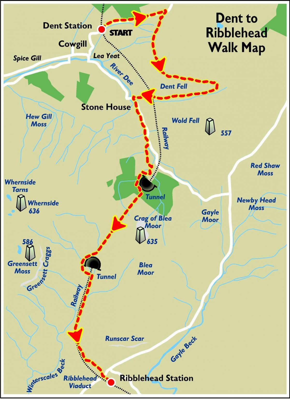
A linear walk which broadly follows the scenic Settle-Carlisle Railway. The route is on good surfaces, with variable gradients.
THE starting point for this week's walk is Dent - a traditional Dales village with a green and cobbled main street.
Its steep-sided valley contrasts beautiful meadows and lush riverside pastures with sparser grassy fells.
A fountain made of pink granite in the village centre commemorates Dent’s links with Adam Sedgwick (1785-1873), professor of geology at Cambridge University, who was one of the greatest field geologists of his time.
The village is also famous for its knitters. In the 18th century, both men and women knitted, often while walking to the fields. Their output of hand-knitted gloves and socks was enormous, providing an important supplementary income.
Their lives are revealed in exhibitions at the Dent Village Heritage Centre.
The village also boasts a12th century church, St Andrew's, which has altar flags made from its most famous mining export, black Dent marble.
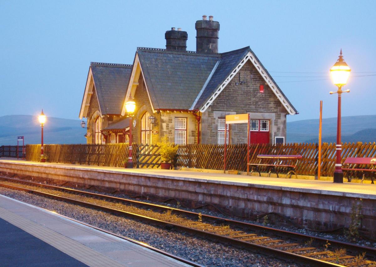
Dent Head's impressive viaduct carries the Settle-Carlisle railway through the dale, offering great views from Ribblesdale in the south to the Eden Valley in the north. Dent Station is England's highest mainline station at 1,150 feet above sea level and was first opened for public use in 1877.
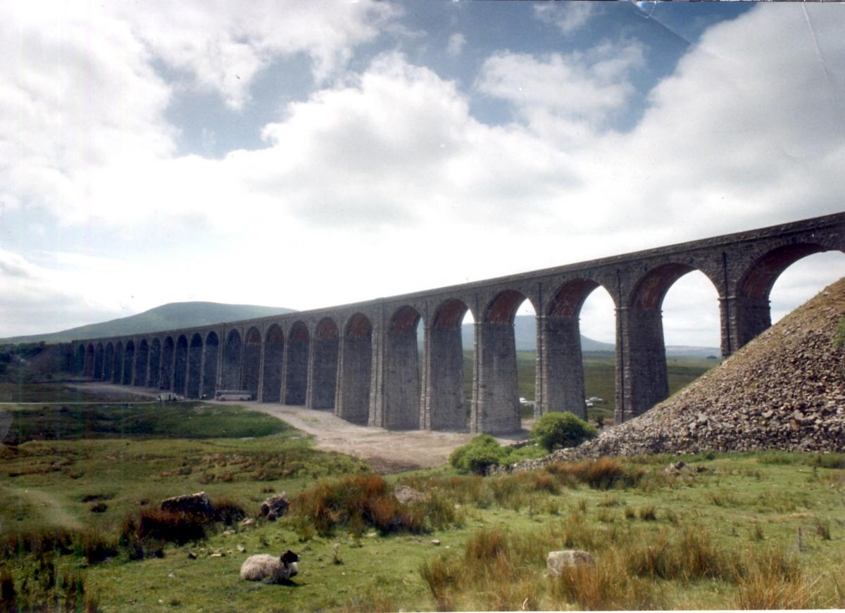
And, the route also gives great views of the scenic line's most famous feature - the 24-arch, 440 yard-long Ribblehead Viaduct, which crosses Batty Moss 100 feet below.
It took five took five years to build, with stone quarried between Selside and Ribblehead. During its construction, 2,000 people mainly ‘navvies’ lived at Batty Moss in temporary huts. When not working, they lived in squalid conditions, with drinking, gambling and fighting their main pastimes. Legend has it that one navvy even sold his wife for a barrel of beer.
For more walks in the Dales, visit the national park website, yorkshiredales.org.uk.
Step by step
• From the Dent station platforms, walk down the approach road to the surfaced road, turn uphill and walk on the verges, where possible, for one mile.
• As the road starts to ease leftwards, look for the wide bridleway on a lane turning right. Take this, which follows the contours for two miles, until you meet with another wide track.
• Turn right here, descending Arten Gill. After one mile pass under the railway where you will meet the Dentdale to Newby Head road beyond.
• Turn left here, and walk along the road for just under a mile (around 15 minutes). Take care to walk on the right hand side of the road and watch out for traffic.
• At Bridge End find the next section of footpath off the road on the right.
• Cross the bridge, turn left and follow the path – aiming at Dent Head Farm, ahead.
• Continue beyond the farm in the same general direction onto a slight ridge and then veer slightly right, around the mouth of the railway tunnel.
• From there follow the track south-west, through conifers at first and then across open moor in a straight line. (Over the top of the rail tunnel).
• Once the railway reappears, descend down the trail on the right hand side of the tracks, until you meet the main path descending from Whernside.
• Once joined, this main path crosses over the railway via a bridge and from there continues to the left of the railway until you reach the road at Ribblehead, where you will find The Station Inn.
• To catch the train, turn right onto the road for 100m, where you’ll find the Ribblehead station access road leading off to the left just before the road goes under the railway line.
Fact file
Distance: 9.2 miles (14.7 km)
Time: a minimum of about four-and-a-half hours
Map: Ordnance Survey Explorer Series (1:25 000) map OL2
Parking: Limited availabliltiy at Dent Station (
Toilets: None
Refreshments: The Station Inn at Ribblehead


Comments: Our rules
We want our comments to be a lively and valuable part of our community - a place where readers can debate and engage with the most important local issues. The ability to comment on our stories is a privilege, not a right, however, and that privilege may be withdrawn if it is abused or misused.
Please report any comments that break our rules.
Read the rules here